It begun with having no idea what I wanted to do in Geography. Then my teacher suggested GIS.
….still had no idea what that was.
That was my canon event.
My interest in maps was there, from my
Dora The Explorer Days.
The serious pursuit began at University.

How it begun.


Welcome to my Map Portfolio
Hence forward are my map creations and some context. Best if viewed on a desktop.
Applied GIS and Remote Sensing Course Maps (2019)
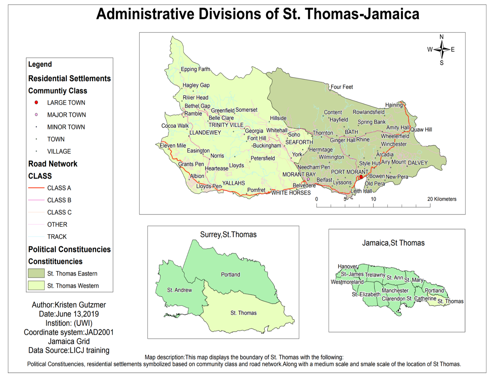
Figure 1 .Administrative Divisions of St.Thomas,Jamaica,Arc GISThis map was an assignment for GIS and remote Sensing course at the University of the west Indies.
Provided the shapefile package, the purpose of the assignment was to deem the best way to represent the parish of St Thomas with its political constituencies, residential settlements and road networks.

Figure 2 .Hurricane Sandy Path 2012,Jamaica Arc GIS.A large-scale map was made displaying the path of Hurricane Sandy 2012.
The map shows a multiple ring buffer zone around the path to highlight the extent that communities were damaged.
The obstacle of the assignment was to change the projection of the hurricane’s path coordinate system.
The hurricane path was projected to fit the JAD2001 coordinate system.
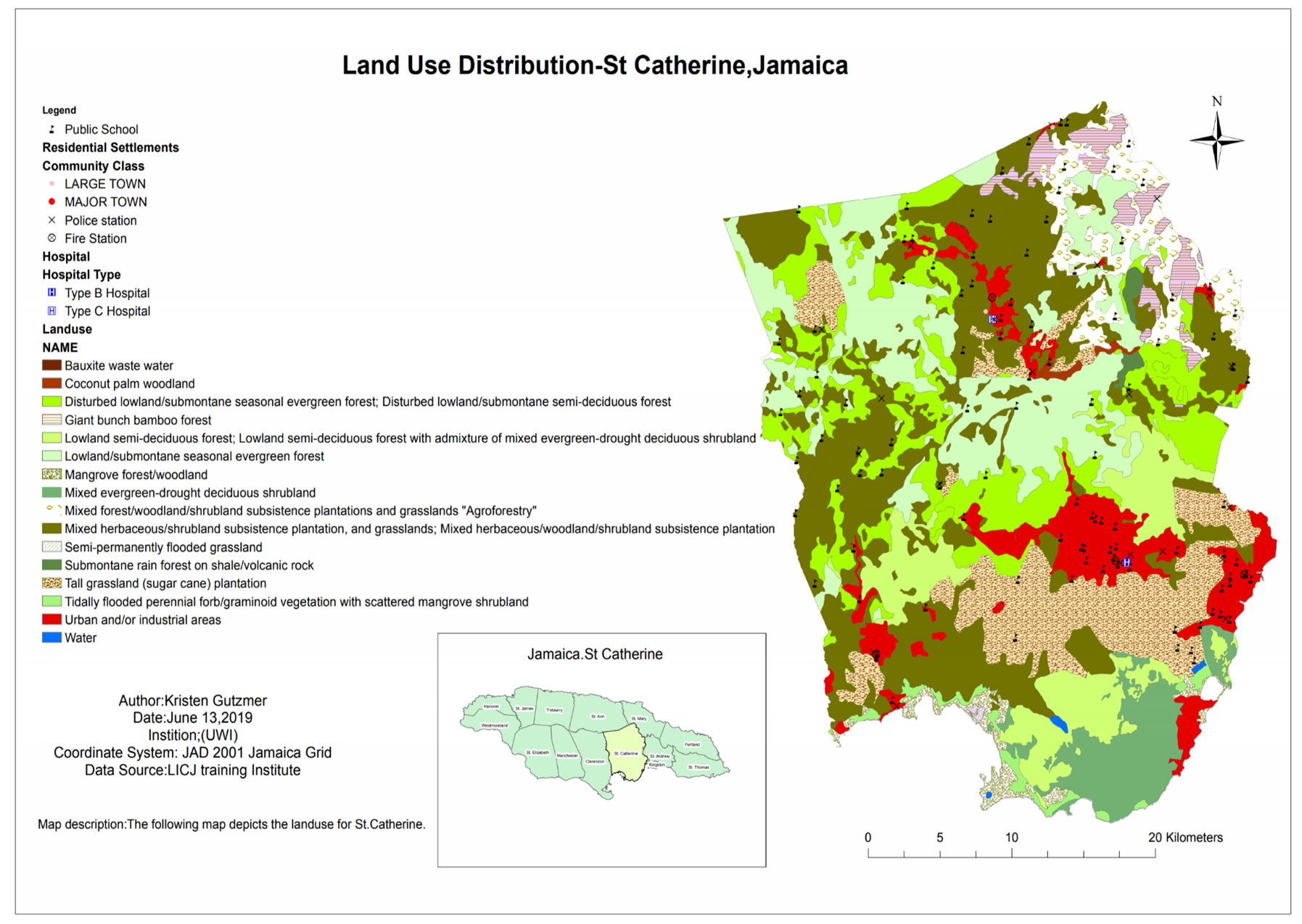
Figure 3. Land use distribution of St Catherine, Jamaica.This large-scale map shows the boundary of St. Catherine with land use having their individual appropriate symbology.
The land use shows settlements in relation to the vegetation type and water bodies.
In creating this map several land use symbols had to be deleted due to repetition and merged. The elements were then manipulated to give this desired format,

Figure 4. Morant Bay sphere of influence, Jamaica.A large-scale map showing the Sphere of Influence of Morant Bay, the capital of St. Thomas was requested.
To show the sphere of Influence a multiple ring buffer was added around the capital to show a correlation between the location of the capitals with amenities and residential settlements..

Figure 5. depiction of Hospitals ,road network and residential settlement, QGISThis was an introduction to a new software QGIS.
The purpose was to compare it to Arc Map.
The main difference noticed was the layout of the app’s navigation interface.
Also, the limitation in customizing features looks.
After playing around with the software the following map was produced.


Figure 6 ,7. Image classification, supervised and unsupervised classification of Hope Gardens Complex Land use, St Andrew Jamaica
The next focus of the course was image classification. Two types of maps were made for learning image classification in Arc Maps.(supervised and Unsupervised)
The image was clipped from Bing Maps and then georeferenced in ArcMap.
The training sample Manager was launched to classify the different areas of land use. This was done for three classes.
Several post classification processing was done as well for both maps in aim of refining the map.

This map shows the Geography and Geology Department as well as its surrounding environs on the University Campus.
To create the map, field data was collected. Google earth was used to determine the study area as well as to conduct a reconnaissance of the Geography and Geology Department. The types of features to be captured and the scale (point, line or polygon) was also determined. A data dictionary was developed using GPS Pathfinder where attributes of the selected featured were created. The data dictionary was then uploaded onto a Trimble GPS unit followed by conducting field data collection by mapping the features. After data collection, the mapped features were transferred to pathfinder where the data was converted into a format that would be able to open in ArcMap. The GPS features were then opened in ArcMap and overlaid a base satellite imagery. The features were then symbolized based on the captured attributes. Correction and editing of the data were done to ensure accuracy as well as to clean up the mapped features. A title and other map elements were added to complete the map.
Figure 6 ,7. Digitized Map of Department of Geography and Geology using Trimble GPS.

THESIS MAPS
The Role of Airbnb growth in Urban Tourism in The Kingston Metropolitan Area.

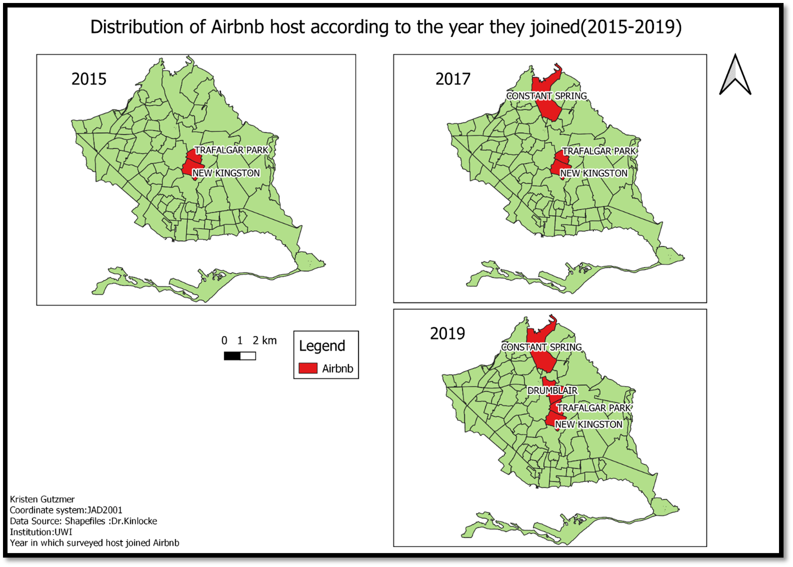


Traditional tourism has always been in the spotlight for Jamaica, with my thesis I shed some light on a sub-branch of tourism, urban tourism. Airbnb has had explosive growth worldwide and Jamaica has not been left out. The suburban community of Mona Heights was used as a case study for my research question “What is the role of Airbnb growth in the Kingston Metropolitan area”